Waterways always a driving source of growth for Hamilton County
-
-
Freeman-Journal photo by Kolleen Taylor
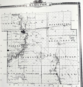
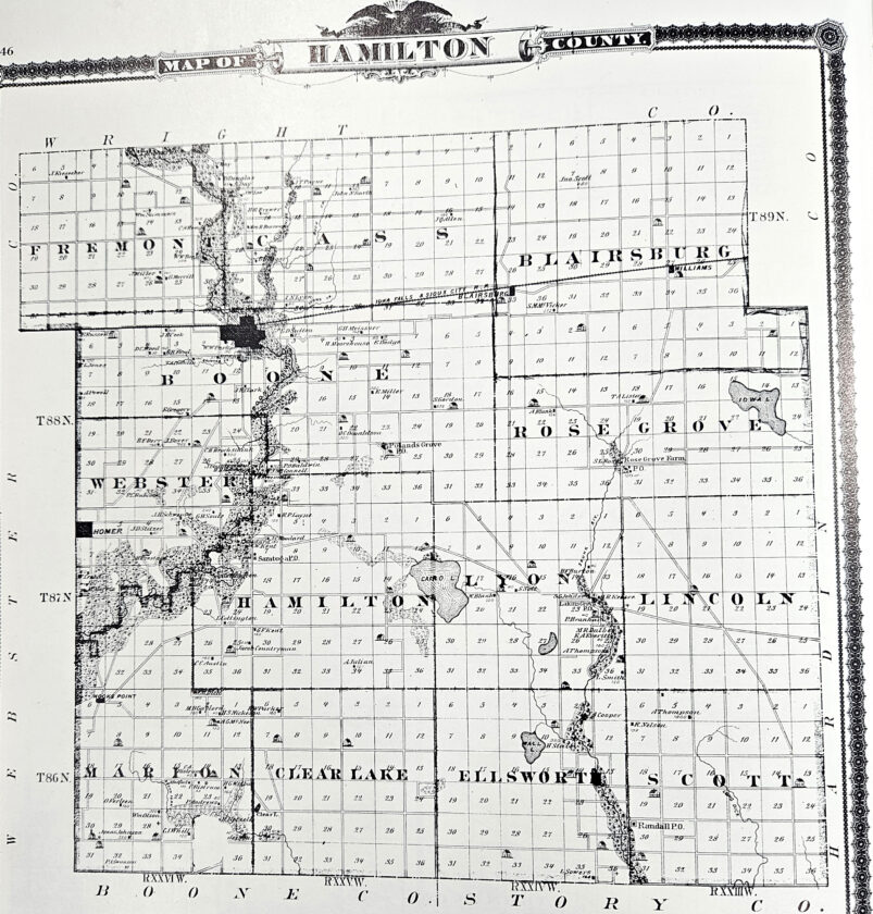
This 1875 map of Hamilton County show the three original lakes, circled in the county. The two largest lakes Cairo Lake and Iowa Lake were drained and now are farmed.
Freeman-Journal photo by Kolleen Taylor
This 1875 map of Hamilton County show the three original lakes, circled in the county. The two largest lakes Cairo Lake and Iowa Lake were drained and now are farmed.
As early settlers moved westward, and the eastern states were establishing business and industry to support their communities, the paths to reach Iowa were varied.
The first step to head west was to pass through the Appalachian mountains. There were only two options: by land or waterway.
The waterways had advantages, as settlements were springing up along the rivers and streams. With its borders of the Mississippi River and the Missouri River, Iowa was naturally carved out by water. Hamilton County itself, was considered “well watered” by streams. Hamilton County originally had large areas of swamp or marsh lands, in addition to three areas where there were actual lakes.
Those lake areas fed the lakes and marshes. As farmers began tiling their grounds to make the fertile soil more suitable for production, some areas were easier to develop than others.
The waterways in Hamilton County lead into several different rivers. The Boone river travels the west tier of townships from north to south and this river empties from Brewer Creek, Lyon creek and White Fox creek, in addition to a number of small rivulets.
The Skunk river, with its branches, traverses the eastern part of the county.
At one time there were three lakes within the county: The first, Lake Cairo, known as “Mud Lake” was located near the center of the county on the line between Hamilton and Lyon township. This lake formerly covered about 1200 acres and was a great rendezvous for wild game. It was at one time drained.
In the east part of the county in Rose Grove township was Iowa Lake, almost as large as Mud lake. This lake was not deep, but it covered almost 900 acres of land in sections 14, 15, 22 and 23. This was the largest and most expensive drainage project of the county. This was converted into farm land.
In the southern part of the county in Ellsworth township is Wall Lake, almost entirely surrounded by Morainic hills. Known as Little Wall Lake today, it is still in existence and now has cabins and campgrounds. But of all the three lakes, it was only about half the size of the other lakes. It was originally shallow and filled with rushes and other aquatic plants. Today, Little Wall Lake is a destination for fishermen, boating enthusiasts, and all types of vacationers.
The Boone river rises in the northwestern part of Hancock county and flows in a southeasterly direction to Webster City,where its general course changes to the south and southwest to its junction with the Des Moines river, just about three miles south of Stratford in Webster County. The total length of the river is 98 miles. It has a drainage basin above Webster City, the area drained by the river being about 100 square miles,
Today some of the areas which were drained for farmland are being re-established as wetlands. The most recent project is southeast of Jewell.
Webster City itself, had areas of swamp, and where the Boone River passes along River Street, at one time, was an area called “Lake Dougherty” with a log hotel on the east bank.
The speculation of current conservation people has been that the Indians who lived here, left the oxbows, creeks, rivers and lakes untouched, allowing them to naturally provide for both the animals and other wildlife that surrounded them.
Efforts to restore wetland areas continue through both private landowners in cooperation with county and state conservationists in an effort to reduce concerns of nitrates in the water sources we have flowing through the county.
Water testing throughout the county has shown our waterways have improved where there is adequate greenspace buffering the creeks and rivers, a standard which may not have been as necessary with the earliest settlers in the county, but something the native americans did naturally, maintaining a safe source of drinking water before nitrates were an issue.
Even though Minnesota was known as the “Land of Lakes”, Iowa presented an equally valuable land and water resource that continues to be monitored and balanced with our daily needs for both agricultural, human and wildlife health.
Local News

Durham says Webster City is ‘investing in itself’ at Gateway
Western Pa. revolutionized energy extraction with new techniques, technology
Fireworks all around
The birthday of the beginning of this country is something to celebrate, and many find fireworks to be their ...
Waterways always a driving source of growth for Hamilton County

Northeast Hamilton Clover Power Ambassadors promote healthy living through leadership and service